Aviation Weather
full text of the classic FAA guide
ALTIMETRY
The altimeter is essentially an aneroid barometer. The difference is the scale. The altimeter is graduated to read increments of height rather than units of pressure. The standard for graduating the altimeter is the standard atmosphere.
ALTITUDE
Altitude seems like a simple term; it means height. But in aviation, it can have many meanings.
True Altitude
Since existing conditions in a real atmosphere are seldom standard, altitude indications on the altimeter are seldom actual or true altitudes. True altitude is the actual or exact altitude above mean sea level. If your altimeter does not indicate true altitude, what does it indicate?
Indicated Altitude
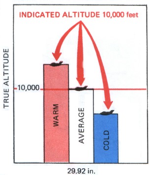
Look again at figure 11 showing the effect of mean temperature on the thickness of the three columns of air. Pressures are equal at the bottoms and equal at the tops of the three layers. Since the altimeter is essentially a barometer, altitude indicated by the altimeter at the top of each column would be the same. To see this effect more clearly, study figure 14. Note that in the warm air, you fly at an altitude higher than indicated. In the cold air, you are at an altitude lower than indicated.
Height indicated on the altimeter also changes with changes in surface pressure. A movable scale on the altimeter permits you to adjust for surface pressure, but you have no means of adjusting the instrument for mean temperature of the column of air below you. Indicated altitude is the altitude above mean sea level indicated on the altimeter when set at the local altimeter setting. But what is altimeter setting?
Altimeter Setting
Since the altitude scale is adjustable, you can set the altimeter to read true altitude at some specified height. Takeoff and landing are the most critical phases of flight; therefore, airport elevation is the most desirable altitude for a true reading of the altimeter. Altimeter setting is the value to which the scale of the pressure altimeter is set so the altimeter indicates true altitude at field elevation.
In order to ensure that your altimeter reading is compatible with altimeter readings of other aircraft in your vicinity, keep your altimeter setting current. Adjust it frequently in flight to the altimeter setting reported by the nearest tower or weather reporting station. Figure 15 shows the trouble you can encounter if you are lax in adjusting your altimeter in flight. Note that as you fly from high pressure to low pressure, you are lower than your altimeter indicates.
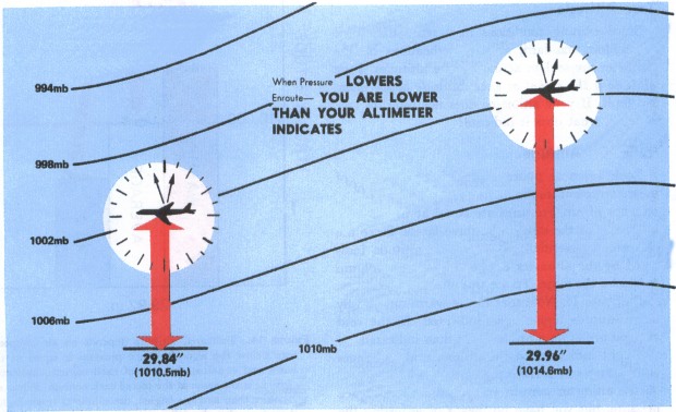
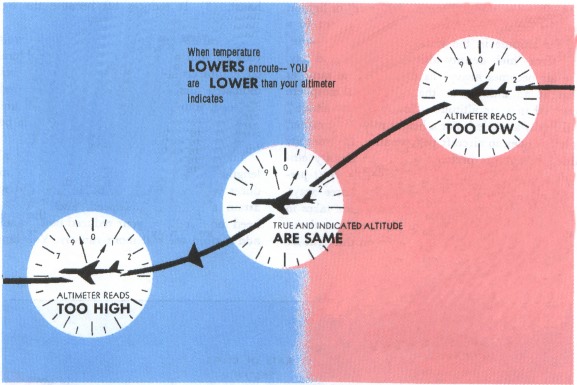
Figure 16 shows that as you fly from warm to cold air, your altimeter reads too high—you are lower than your altimeter indicates. Over flat terrain this lower than true reading is no great problem; other aircraft in the vicinity also are flying indicated rather than true altitude, and your altimeter readings are compatible. If flying in cold weather over mountainous areas, however, you must take this difference between indicated and true altitude into account. You must know that your true altitude assures clearance of terrain, so you compute a correction to indicated altitude.
Corrected (Approximately True) Altitude
If it were possible for a pilot always to determine mean temperature of the column of air between the aircraft and the surface, flight computers would be designed to use this mean temperature in computing true altitude. However, the only guide a pilot has to temperature below him is free air temperature at his altitude. Therefore, the flight computer uses outside air temperature to correct indicated altitude to approximate true altitude. Corrected altitude is indicated altitude corrected for the temperature of the air column below the aircraft, the correction being based on the estimated departure of the existing temperature from standard atmospheric temperature. It is a close approximation to true altitude and is labeled true altitude on flight computers. It is close enough to true altitude to be used for terrain clearance provided you have your altimeter set to the value reported from a nearby reporting station.
Pilots have met with disaster because they failed to allow for the difference between indicated and true altitude. In cold weather when you must clear high terrain, take time to compute true altitude.
FAA regulations require you to fly indicated altitude at low levels and pressure altitude at high levels (at or above 18,000 feet at die time this book was printed). What is pressure altitude?
Pressure Altitude
In the standard atmosphere, sea level pressure is 29.92 inches of mercury or 1013.2 millibars. Pressure falls at a fixed rate upward through this hypothetical atmosphere. Therefore, in the standard atmosphere, a given pressure exists at any specified altitude. Pressure altitude is the altitude in the standard atmosphere where pressure is the same as where you are. Since at a specific pressure altitude, pressure is everywhere the same, a constant pressure surface defines a constant pressure altitude. When you fly a constant pressure altitude, you are flying a constant pressure surface.
You can always determine pressure altitude from your altimeter whether in flight or on the ground. Simply set your altimeter at the standard altimeter setting of 29.92 inches, and your altimeter indicates pressure altitude.
A conflict sometimes occurs near the altitude separating flights using indicated altitude from those using pressure altitude. Pressure altitude on one aircraft and indicated altitude on another may indicate altitude separation when, actually, the two are at the same true altitude. All flights using pressure altitude at high altitudes are IFR controlled flights. When this conflict occurs, air traffic controllers prohibit IFR flight at the conflicting altitudes.
DENSITY ALTITUDE
What is density altitude? Density altitude simply is the altitude in the standard atmosphere where air density is the same as where you are. Pressure, temperature, and humidity determine air density. On a hot day, the air becomes “thinner” or lighter, and its density where you are is equivalent to a higher altitude in the standard atmosphere—thus the term “high density altitude.” On a cold day, the air becomes heavy; its density is the same as that at an altitude in the standard atmosphere lower than your altitude—“low density altitude.”
Density altitude is not a height reference; rather, it is an index to aircraft performance. Low density altitude increases performance. High density altitude is a real hazard since it reduces aircraft performance. It affects performance in three ways. (1) It reduces power because the engine takes in less air to support combustion. (2) It reduces thrust because the propeller gets less grip on the light air or a jet has less mass of gases to spit out the exhaust. (3) It reduces lift because the light air exerts less force on the airfoils.
You cannot detect the effect of high density altitude on your airspeed indicator. Your aircraft lifts off, climbs, cruises, glides, and lands at the prescribed indicated airspeeds. But at a specified indicated airspeed, your true airspeed and your groundspeed increase proportionally as density altitude becomes higher.
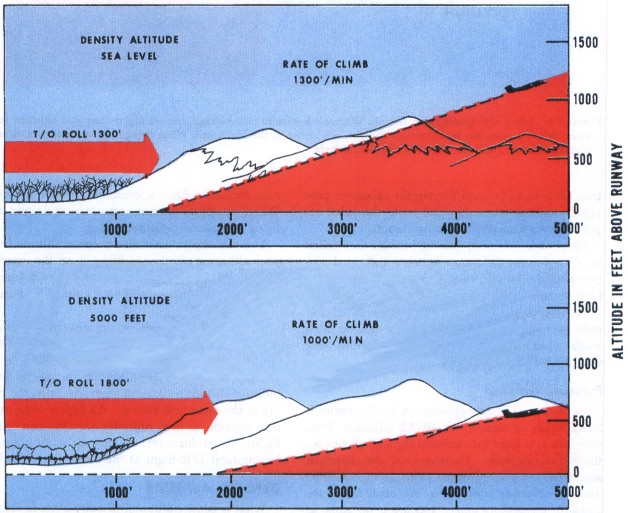
The net results are that high density altitude lengthens your takeoff and landing rolls and reduces your rate of climb. Before lift-off, you must attain a faster groundspeed, and therefore, you need more runway; your reduced power and thrust add a need for still more runway. You land at a faster groundspeed and, therefore, need more room to stop. At a prescribed indicated airspeed, you are flying at a faster true airspeed, and therefore, you cover more distance in a given time which means climbing at a more shallow angle. Add to this the problems of reduced power and rate of climb, and you are in double jeopardy in your climb. Figure 17 shows the effect of density altitude on takeoff distance and rate of climb.
High density altitude also can be a problem at cruising altitudes. When air is abnormally warm, the high density altitude lowers your service ceiling. For example, if temperature at 10,000 feet pressure altitude is 20° C, density altitude is 12,700 feet. (Check this on your flight computer.) Your aircraft will perform as though it were at 12,700 indicated with a normal temperature of − 8° C.
To compute density altitude, set your altimeter at 29.92 inches or 1013.2 millibars and read pressure altitude from your altimeter. Read outside air temperature and then use your flight computer to get density altitude. On an airport served by a weather observing station, you usually can get density altitude for the airport from the observer. Section 16 of AVIATION WEATHER SERVICES has a graph for computing density altitude if you have no flight computer handy.
Table of Contents
Previous Section: Atmospheric Pressure
Next Section: In Closing
A PDF version of this book is available here. You may be able to buy a printed copy of the book from amazon.com.