Aviation Weather
full text of the classic FAA guide
FRONTS
As air masses move out of their source regions, they come in contact with other air masses of different properties. The zone between two different air masses is a frontal zone or front. Across this zone, temperature, humidity and wind often change rapidly over short distances.
DISCONTINUITIES
When you pass through a front, the change from the properties of one air mass to those of the other is sometimes quite abrupt. Abrupt changes indicate a narrow frontal zone. At other times, the change of properties is very gradual indicating a broad and diffuse frontal zone.
Temperature
Temperature is one of the most easily recognized discontinuities across a front. At the surface, the passage of a front usually causes noticeable temperature change. When flying through a front, you note a significant change in temperature, especially at low altitudes. Remember that the temperature change, even when gradual, is faster and more pronounced than a change during a flight wholly within one air mass. Thus, for safety, obtain a new altimeter setting after flying through a front. Chapter 3 discussed the effect of a temperature change on the aircraft altimeter.
Dew Point
As you learned in Chapter 5, dew point temperature is a measure of the amount of water vapor in the air. Temperature—dew point spread is a measure of the degree of saturation. Dew point and temperature—dew point spread usually differ across a front. The difference helps identify the front and may give a clue to differences of cloudiness and/or fog.
Wind
Wind always changes across a front. Wind discontinuity may be in direction, in speed, or in both. Be alert for a wind shift when flying in the vicinity of a frontal surface; if the wind shift catches you unaware it can get you off course or even lost in a short time. The relatively sudden change in wind also creates wind shear, and you will study its significance in the next chapter, “Turbulence.”
Pressure
A front lies in a pressure trough, and pressure generally is higher in the cold air. Thus, when you cross a front directly into colder air, pressure usually rises abruptly. When you approach a front toward warm air, pressure generally falls until you cross the front and then remains steady or falls slightly in the warm air. However, pressure patterns vary widely across fronts, and your course may not be directly across a front. The important thing to remember is that when crossing a front, you will encounter a difference in the rate of pressure change; be especially alert in keeping your altimeter setting current.
TYPES OF FRONTS
The three principal types of fronts are the cold front, the warm front, and the stationary front.
Cold Front
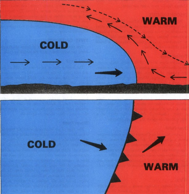
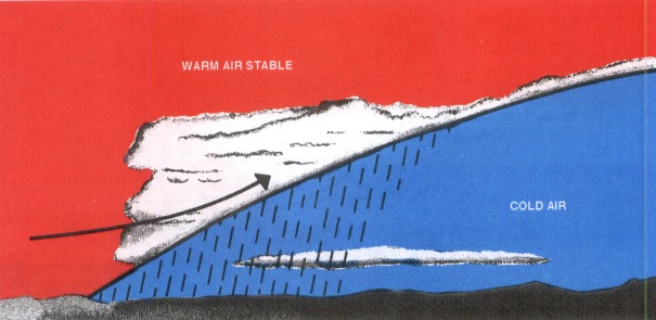
The leading edge of an advancing cold air mass is a cold front. At the surface, cold air is overtaking and replacing warmer air. Cold fronts move at about the speed of the wind component perpendicular to the front just above the frictional layer. Figure 59 shows the vertical cross section of a cold front and the symbol depicting it on a surface weather chart. A shallow cold air mass or a slow moving cold front may have a frontal slope more like a warm front shown in figure 60.
Warm Front
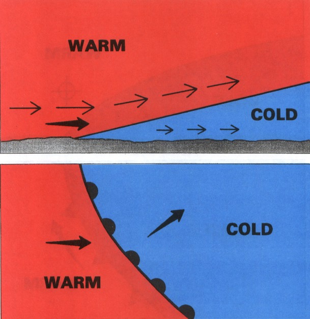
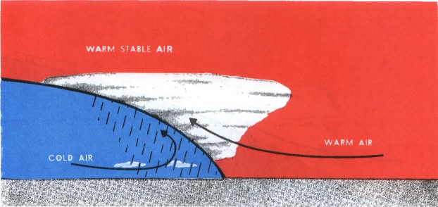
The edge of an advancing warm air mass is a warm front—warmer air is overtaking and replacing colder air. Since the cold air is denser than the warm air, the cold air hugs the ground. The warm air slides up and over the cold air and lacks direct push on the cold air. Thus, the cold air is slow to retreat in advance of the warm air. This slowness of the cold air to retreat produces a frontal slope that is more gradual than the cold frontal slope as shown in figure 60. Consequently, warm fronts on the surface are seldom as well marked as cold fronts, and they usually move about half as fast when the general wind flow is the same in each case.
Stationary Fronts
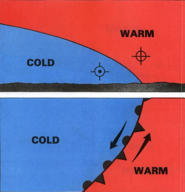
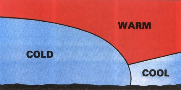
When neither air mass is replacing the other, the front is stationary. Figure 61 shows a cross section of a stationary front and its symbol on a surface chart. The opposing forces exerted by adjacent air masses of different densities are such that the frontal surface between them shows little or no movement. In such cases, the surface winds tend to blow parallel to the frontal zone. Slope of a stationary front is normally shallow, although it may be steep depending on wind distribution and density difference.
FRONTAL WAVES AND OCCLUSION
Frontal waves and cyclones (areas of low pressure) usually form on slow-moving cold fronts or on stationary fronts. The life cycle and movement of a cyclone is dictated to a great extent by the upper wind flow.
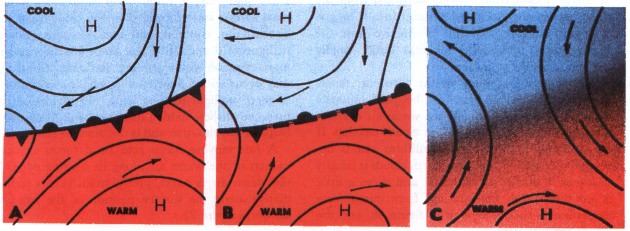
In the initial condition of frontal wave development in figure 62, the winds on both sides of the front are blowing parallel to the front (A). Small disturbances then may start a wavelike bend in the front (B).
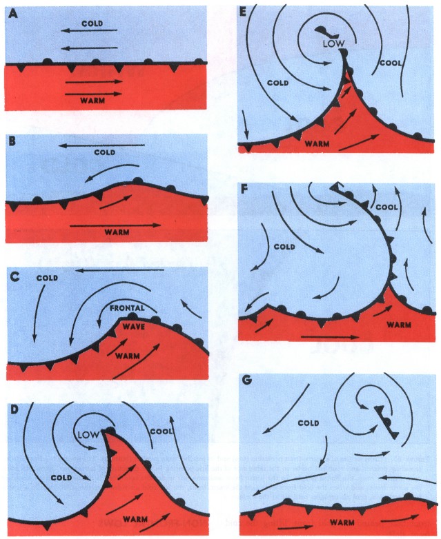
If this tendency persists and the wave increases in size, a cyclonic (counterclockwise) circulation develops. One section of the front begins to move as a warm front, while the section next to it begins to move as a cold front (C). This deformation is a frontal wave.
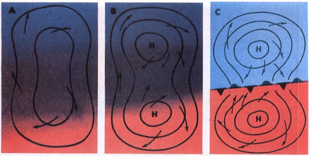
The pressure at the peak of the frontal wave falls, and a low-pressure center forms. The cyclonic circulation becomes stronger, and the surface winds are now strong enough to move the fronts; the cold front moves faster than the warm front (D). When the cold front catches up with the warm front, the two of them occlude (close together). The result is an occluded front or, for brevity, an occlusion (E). This is the time of maximum intensity for the wave cyclone. Note that the symbol depicting the occlusion is a combination of the symbols for the warm and cold fronts.
As the occlusion continues to grow in length, the cyclonic circulation diminishes in intensity and the frontal movement slows down (F). Sometimes a new frontal wave begins to form on the long westward-trailing portion of the cold front (F,G), or a secondary low pressure system forms at the apex where the cold front and warm front come together to form the occlusion. In the final stage, the two fronts may have become a single stationary front again. The low center with its remnant of the occlusion is disappearing (G).
Figure 63 indicates a warm-front occlusion in vertical cross section. This type of occlusion occurs when the air is colder in advance of the warm front than behind the cold front, lifting the cold front aloft.
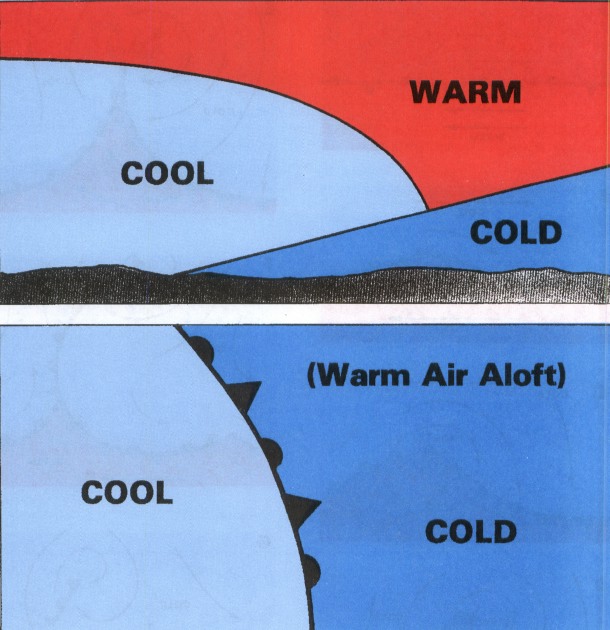
Figure 64 indicates a cold-front occlusion in vertical cross section. This type of occlusion occurs when the air behind the cold front is colder than the air in advance of the warm front, lifting the warm front aloft.
NON-FRONTAL LOWS
Since fronts are boundaries between air masses of different properties, fronts are not associated with lows lying solely in a homogeneous air mass. Nonfrontal lows are infrequent east of the Rocky Mountains in midlatitudes but do occur occasionally during the warmer months. Small nonfrontal lows over the western mountains are common as is the semistationary thermal low in extreme Southwestern United States. Tropical lows are also nonfrontal.
FRONTOLYSIS AND FRONTOGENESIS
As adjacent air masses modify and as temperature and pressure differences equalize across a front, the front dissipates. This process, frontolysis, is illustrated in figure 65. Frontogenesis is the generation of a front. It occurs when a relatively sharp zone of transition develops over an area between two air masses which have densities gradually becoming more and more in contrast with each other. The necessary wind flow pattern develops at the same time. Figure 66 shows an example of frontogenesis with the symbol.
FRONTAL WEATHER
In fronts, flying weather varies from virtually clear skies to extreme hazards including hail, turbulence, icing, low clouds, and poor visibility. Weather occurring with a front depends on (1) the amount of moisture available, (2) the degree of stability of the air that is forced upward, (3) the slope of the front, (4) the speed of frontal movement, and (5) the upper wind flow.
Sufficient moisture must be available for clouds to form, or there will be no clouds. As an inactive front comes into an area of moisture, clouds and precipitation may develop rapidly. A good example of this is a cold front moving eastward from the dry slopes of the Rocky Mountains into a tongue of moist air from the Gulf of Mexico over the Plains States. Thunderstorms may build rapidly and catch a pilot unaware.
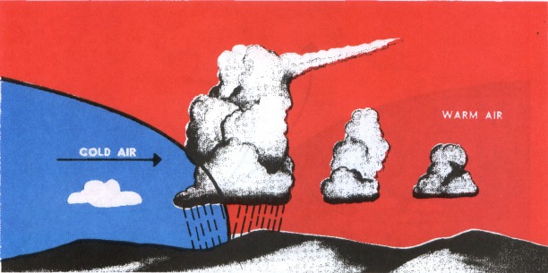
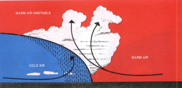
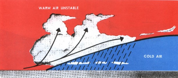
The degree of stability of the lifted air determines whether cloudiness will be predominately stratiform or cumuliform. If the warm air overriding the front is stable, stratiform clouds develop. If the warm air is unstable, cumuliform clouds develop. Precipitation from stratiform clouds is usually steady as illustrated in figure 67 and there is little or no turbulence. Precipitation from cumuliform clouds is of a shower type as in figure 68, and the clouds are turbulent.
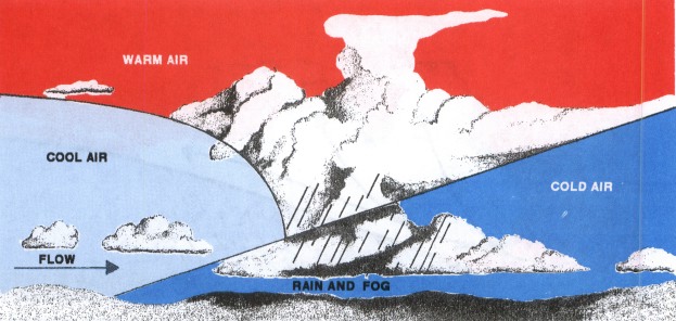
Shallow frontal surfaces tend to give extensive cloudiness with large precipitation areas (figure 69). Widespread precipitation associated with a gradual sloping front often causes low stratus and fog. In this case, the rain raises the humidity of the cold air to saturation. This and related effects may produce low ceiling and poor visibility over thousands of square miles. If temperature of the cold air near the surface is below freezing but the warmer air aloft is above freezing, precipitation falls as freezing rain or ice pellets; however, if temperature of the warmer air aloft is well below freezing, precipitation forms as snow.
When the warm air overriding a shallow front is moist and unstable, the usual widespread cloud mass forms; but embedded in the cloud mass are altocumulus, cumulus, and even thunderstorms as in figures 70 and 71. These embedded storms are more common with warm and stationary fronts but may occur with a slow moving, shallow cold front. A good preflight briefing helps you to foresee the presence of these hidden thunderstorms. Radar also helps in this situation and is discussed in chapter 11.
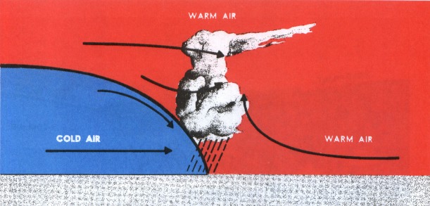
A fast moving, steep cold front forces upward motion of the warm air along its leading edge. If the warm air is moist, precipitation occurs immediately along the surface position of the front as shown in figure 72.
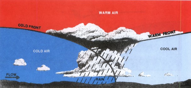
Since an occluded front develops when a cold front overtakes a warm front, weather with an occluded front is a combination of both warm and cold frontal weather. Figures 73 and 74 show warm and cold occlusions and associated weather.
A front may have little or no cloudiness associated with it. Dry fronts occur when the warm air aloft is flowing down the frontal slope or the air is so dry that any cloudiness that occurs is at high levels.
The upper wind flow dictates to a great extent the amount of cloudiness and rain accompanying a frontal system as well as movement of the front itself. Remember in chapter 4 we said that systems tend to move with the upper winds. When winds aloft blow across a front, it tends to move with the wind. When winds aloft parallel a front, the front moves slowly if at all. A deep, slow moving trough aloft forms extensive cloudiness and precipitation, while a rapid moving minor trough more often restricts weather to a rather narrow band. However, the latter often breeds severe, fast moving, turbulent spring weather.
INSTABILITY LINE
An instability line is a narrow, nonfrontal line or band of convective activity. If the activity is fully developed thunderstorms, figure 75, the line is a squall line (chapter 11, “Thunderstorms”). Instability lines form in moist unstable air. An instability line may develop far from any front. More often, it develops ahead of a cold front, and sometimes a series of these lines move out ahead of the front. A favored location for instability lines which frequently erupt into severe thunderstorms is a dew point front or dry line.
DEW POINT FRONT OR DRY LINE
During a considerable part of the year, dew point fronts are common in Western Texas and New Mexico northward over the Plains States. Moist air flowing north from the Gulf of Mexico abuts the dryer and therefore slightly denser air flowing from the southwest. Except for moisture differences, there is seldom any significant air mass contrast across this “Front”; and therefore, it is commonly called a “dry line.” Nighttime and early morning fog and low-level clouds often prevail on the moist side of the line while generally clear skies mark the dry side. In spring and early summer over Texas, Oklahoma, and Kansas, and for some distance eastward, the dry line is a favored spawning area for squall lines and tornadoes.
Table of Contents
Previous Section: Air Masses
Next Section: Fronts and Flight Planning
A PDF version of this book is available here. You may be able to buy a printed copy of the book from amazon.com.