Aviation Weather
full text of the classic FAA guide
HAZE AND SMOKE
Haze is a concentration of salt particles or other dry particles not readily classified as dust or other phenomenon. It occurs in stable air, is usually only a few thousand feet thick, but sometimes may extend as high as 15,000 feet. Haze layers often have definite tops above which horizontal visibility is good. However, downward visibility from above a haze layer is poor, especially on a slant. Visibility in haze varies greatly depending upon whether the pilot is facing the sun. Landing an aircraft into the sun is often hazardous if haze is present.
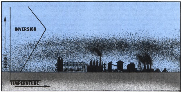
Smoke concentrations form primarily in industrial areas when air is stable. It is most prevalent at night or early morning under a temperature inversion but it can persist throughout the day. Figure 120 illustrates smoke trapped under a temperature inversion.
When skies are clear above haze or smoke, visibility generally improves during the day; however, the improvement is slower than the clearing of fog. Fog evaporates, but haze or smoke must be dispersed by movement of air. Haze or smoke may be blown away; or heating during the day may cause convective mixing spreading the smoke or haze to a higher altitude, decreasing the concentration near the surface. At night or early morning, radiation fog or stratus clouds often combine with haze or smoke. The fog and stratus may clear rather rapidly during the day but the haze and smoke will linger. A heavy cloud cover above haze or smoke may block sunlight preventing dissipation; visibility will improve little, if any, during the day.
Table of Contents
Previous Section: Low Stratus Clouds
Next Section: Blowing Restrictions to Visibility
A PDF version of this book is available here. You may be able to buy a printed copy of the book from amazon.com.