Aviation Weather
full text of the classic FAA guide
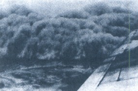
BLOWING RESTRICTIONS TO VISIBILITY
Strong wind lifts blowing dust in both stable and unstable air. When air is unstable, dust is lifted to great heights (as much as 15,000 feet) and may be spread over wide areas by upper winds. Visibility is restricted both at the surface and aloft. When air is stable, dust does not extend to as great a height as in unstable air and usually is not as widespread. Dust, once airborne, may remain suspended and restrict visibility for several hours after the wind subsides. Figure 121 is a photograph of a dust storm moving in with an approaching cold front.
Blowing sand is more local than blowing dust; the sand is seldom lifted above 50 feet. However, visibilities within it may be near zero. Blowing sand may occur in any dry area where loose sand is exposed to strong wind.
Blowing snow can be troublesome. Visibility at ground level often will be near zero and the sky may become obscured when the particles are raised to great heights.
Table of Contents
Previous Section: Haze and Smoke
Next Section: Precipitation
A PDF version of this book is available here. You may be able to buy a printed copy of the book from amazon.com.