Aviation Weather
full text of the classic FAA guide
CLEAR AIR TURBULENCE
Clear air turbulence (CAT) implies turbulence devoid of clouds. However, we commonly reserve the term for high level wind shear turbulence, even when in cirrus clouds.
Cold outbreaks colliding with warm air from the south intensify weather systems in the vicinity of the jet stream along the boundary between the cold and warm air. CAT develops in the turbulent energy exchange between the contrasting air masses. Cold and warm advection along with strong wind shears develop near the jet stream, especially where curvature of the jet stream sharply increases in deepening upper troughs. CAT is most pronounced in winter when temperature contrast is greatest between cold and warm air.
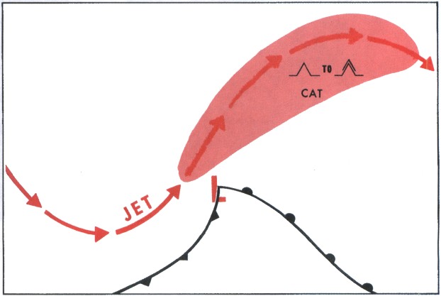
A preferred location of CAT is in an upper trough on the cold (polar) side of the jet stream. Another frequent CAT location, shown in figure 129, is along the jet stream north and northeast of a rapidly deepening surface low.
Even in the absence of a well-defined jet stream, CAT often is experienced in wind shears associated with sharply curved contours of strong lows, troughs, and ridges aloft, and in areas of strong, cold or warm air advection. Also mountain waves can create CAT. Mountain wave CAT may extend from the mountain crests to as high as 5,000 feet above the tropopause, and can range 100 miles or more downstream from the mountains.
CAT can be encountered where there seems to be no reason for its occurrence. Strong winds may carry a turbulent volume of air away from its source region. Turbulence intensity diminishes downstream, but some turbulence still may be encountered where it normally would not be expected. CAT forecast areas are sometimes elongated to indicate probable turbulence drifting downwind from the main source region.
A forecast of turbulence specifies a volume of airspace which is quite small when compared to the total volume of airspace used by aviation, but is relatively large compared to the localized extent of the hazard. Since turbulence in the forecast volume is patchy, you can expect to encounter it only intermittently and possibly not at all. A flight through forecast turbulence, on the average, encounters only light and annoying turbulence 10 to 15 percent of the time; about 2 to 3 percent of the time there is a need to have all objects secured; the pilot experiences control problems only about two-tenths of 1 percent of the time—odds of this genuinely hazardous turbulence are about 1 in 500.
Look again at figure 126. Where are the most probable areas of GAT? Turbulence would be greatest near the windspeed maxima, usually on the polar sides where there is a combination of strong wind shear, curvature in the flow, and cold air advection. These areas would be to the northwest of Vancouver Island, from north of the Great Lakes to east of James Bay and over the Atlantic east of Newfoundland. Also, turbulence in the form of mountain waves is probable in the vicinity of the jet stream from southern California across the Rockies into the Central Plains.
In flight planning, use upper air charts and forecasts to locate the jet stream, wind shears, and areas of most probable turbulence. AVIATION WEATHER SERVICES (AC 00-45) explains in detail how to obtain these parameters. If impractical to avoid completely an area of forecast turbulence, proceed with caution. You will do well to avoid areas where vertical shear exceeds 6 knots per 1,000 feet or horizontal shear exceeds 40 knots per 150 miles.
What can you do if you get into CAT rougher than you care to fly? If near the jet core, you could climb or descend a few thousand feet or you could move farther from the jet core. If caught in CAT not associated with the jet stream, your best bet is to change altitude since you have no positive way of knowing in which direction the strongest shear lies. Pilot reports from other flights, when available, are helpful.
Flight maneuvers increase stresses on the aircraft as does turbulence. The increased stresses are cumulative when the aircraft maneuvers in turbulence. Maneuver gently when in turbulence to minimize stress. The patchy nature of CAT makes current pilot reports extremely helpful to observers, briefers, forecasters, air traffic controllers, and, most important, to your fellow pilots. Always, if at all possible, make inflight weather reports of CAT or other turbulence encounters; negative reports also help when no CAT is experienced where it normally might be expected.
Table of Contents
Previous Section: Cirrus Clouds
Next Section: Condensation Trails
A PDF version of this book is available here. You may be able to buy a printed copy of the book from amazon.com.